The Lemosho route is one of the newer routes on Mount Kilimanjaro. The route begins in the west and, rather than simply intersecting Shira Plateau (like Machame), Lemosho crosses it from Shira Ridge to Shira Camp. Climbers encounter low traffic until the route joins the Machame route. Afterwards, Lemosho follows the same route through Lava Tower, Barranco, and Barafu, known as the southern circuit.
The minimum number of days required for this route is six days, although eight days is ideal.
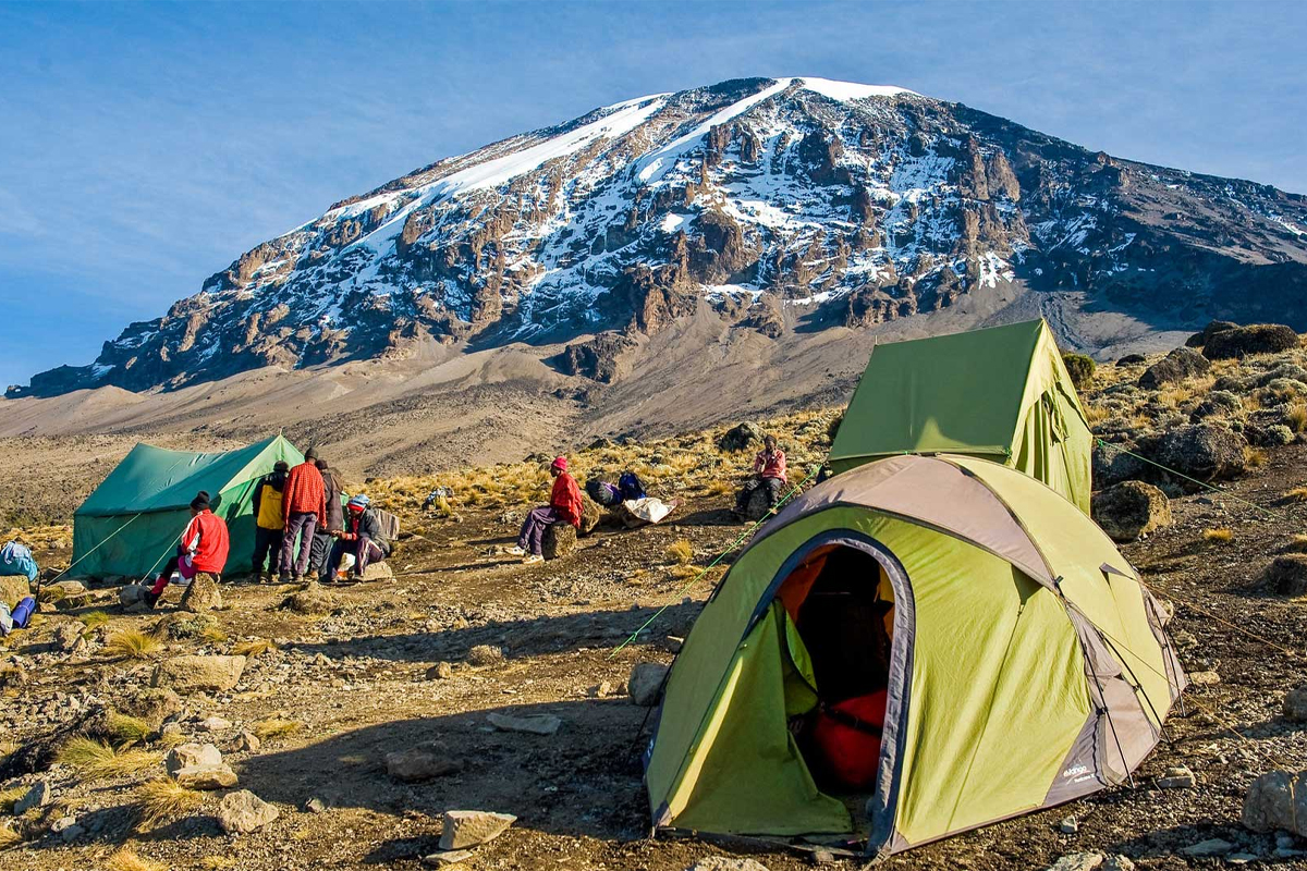
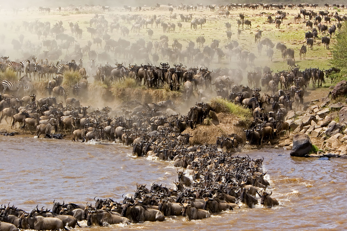
Lemosho is considered the most beautiful route on Kilimanjaro and grants panoramic vistas on various sides of the mountain. It is our favorite route because it offers a great balance of low traffic, scenic views and a high summit success rate. Thus, Lemosho comes highly recommended. Most of our clients use Lemosho.
We are on here for a long time, come join us for the best times
Contrary to popular belief, climbing is hard and tiresome; this route suggests otherwise, come join us for the real fun and joyous moments throughout the climbing to the top of Africa.
Departure/return location
Moshi, Tanzania
Departure Time
Please arrive by 8:30 AM for a departure at 9:30 AM
Return Time
Approximately 8:30 PM
Included
Transport from/to the park gate & airport transfer
Pre & post climb accommodation (B&B) in Moshi/Arusha
Park, camping & rescue fees
Mountain tent & mattress
Professional English speaking guide(s); porters & cook
8 breakfasts; 7 lunches; 6 dinners
Water, tea and coffee with meals
Not Included
Flights
Lunch & dinner in Moshi
Travel insurance
Visa and passport fees
Increases in park fees where applicable
Personal equipment
Sleeping bag
Tips for guide(s), porters & cook
Soda and Alcoholic beverages
Don't miss a chance to experience this amazing climbing; you will be entertained. Our packages are catered to give you a marvelous experience and a heartfelt moment in the mountains.
You're one step closer to your imaginary beautiful destination. Turn this moment into amazing memories that will stick with you forever
We depart Moshi for Londorossi Gate, which takes about 4 hours, where you will complete entry formalities. Then drive to the Lemosho trailhead. Upon arrival at trailhead, we begin hiking through undisturbed forest which winds to the first camp site.
Day 2
Mti Mkubwa to Shira 1 Camp
Elevation: 9,498 ft to 11,500 ft
Distance: 8 km/ 5miles
Hiking Time 5-6 hours
Habitat: Health
We continue on the trail leading out of the rain forest and into a savannah of tall grasses, heather and volcanic rock draped with lichen beards. As we ascend through the lush rolling hills and cross several streams, we reach the Shira Ridge before dropping gently down to Shira 1 Camp. Here we catch our first glimpse of Kibo across the plateau.
Day 3
Shira 1 Camp to Moir Hut
Elevation: 11,500 ft to 13,800 ft
Distance: 11 km/ 7 miles
Hiking Time: 5-7 hours
Habitat: Heath
We explore the Shira Plateau for a full day. It is a gentle walk east on moorland meadows towards Shira 2 Camp. Then we divert from the main trail to Moir Hut, a little used site on the base of Lent Hills. A variety of walks are available on Lent Hills making this an excellent acclimatization opportunity. Shira Plateau is one of the highest plateaus on earth.
Day 4
Moir Hut to Lava Tower
Elevation: 13,800 ft to 15,190 ft
Distance: 7 km/4 miles
Hiking Time: 4-5 hours
Habitat: Alpine Desert
Lava Tower to Barranco Camp
Elevation: 15,190 ft to 13,044 ft
Distance: 3 km/2 miles
Hiking Time: 2-3 hours
Habitat: Alpine Desert
We begin the day climbing up a ridge and then head southeast towards the Lava Tower – a 300 ft tall volcanic rock formation. We descend down to Barranco Camp through the strange but beautiful Senecio Forest to an altitude of 13,000 ft. Although you begin and end the day at the same elevation, the time spent at higher altitude is very beneficial for acclimatization.
Day 5
Barranco Camp to Karanga Camp
Elevation: 13,044 ft to 13,106 ft
Distance: 5 km/3 miles
Hiking Time: 4-5 hours
Habitat: Alpine Desert
We begin the day by descending into a ravine to the base of the Great Barranco Wall. Then we climb the non-technical but steep, nearly 900 ft cliff. From the top of the Barranco Wall we cross a series of hills and valleys until we descend sharply into Karanga Valley. One more steep climb up leads us to Karanga Camp. This is a shorter day meant for acclimatization.
Day 6
Karanga Camp to Barafu Camp
Elevation: 13,106 ft to 15,331 ft
Distance: 4 km/2 miles
Hiking Time: 4-5 hours
Habitat: Alpine Desert
We leave Karanga and hit the junction which connects with the Mweka Trail. We continue up to the rocky section to Barafu Hut. At this point, you have completed the Southern Circuit, which offers views of the summit from many different angles. Here we make camp, rest and enjoy an early dinner to prepare for the summit day. The two peaks of Mawenzi and Kibo are viewable from this position.
Day 7
Barafu Camp to Uhuru Peak
Elevation: 15,331 ft to 19,341 ft
Distance: 5 km/3 miles
Hiking Time: 7-8 hours
Habitat: Arctic
Uhuru Peak to Mweka Camp
Elevation: 19,341 ft to 10,065 ft
Distance: 12 km/7 miles
Hiking Time: 4-6 hours
Habitat: Rain Forest
Very early in the morning (around midnight), we begin our push to the summit. This is the most mentally and physically challenging portion of the trek. The wind and cold at this elevation and time of day can be extreme. We ascend in the darkness for several hours while taking frequent, but short, breaks. Near Stella Point (18,900 ft), you will be rewarded with the most magnificent sunrise you are ever likely to see coming over Mawenzi Peak. Finally, we arrive at Uhuru Peak- the highest point on Mount Kilimanjaro and the continent of Africa.
From the summit, we now make our descent continuing straight down to the Mweka Hut camp site, stopping at Barafu for lunch. The trail is very rocky and can be quite hard on the knees; trekking poles are helpful. Mweka Camp is situated in the upper forest and mist or rain can be expected in the late afternoon. Later in the evening, we enjoy our last dinner on the mountain and a well-earned sleep.
Day 8
Mweka Camp to Mweka Gate
Elevation: 10,065 ft to 5,380 ft
Distance: 10 km/6 miles
Hiking Time: 3-4 hours
Habitat: Rain Forest
On our last day, we continue the descent to Mweka Gate and collect the summit certificates. At lower elevations, it can be wet and muddy. From the gate, we continue another hour to Mweka Village. A vehicle will meet us at Mweka Village to drive us back to the hotel in Moshi.